Eastern Mediterranean tectonics
The eastern Mediterranean is the meeting place of three major tectonic plates, Arabia, Nubia, and Eurasia and two sub-plates Anatolia and Sinai (Figure 1). Although global-wise it is a relatively small region (2% of the Earth's surface), it is tectonically very interesting as containing a variety of tectonic environments. The Red Sea, which separates between Nubia and Arabia, represents a unique environment of mature continental rift or embryonic ocean. Continental collision between Arabia and Eurasia occurs in the Caucuses, which are located between the Black and the Caspian Seas. Oceanic collision occurs along the Hellenic and Cyprian Arcs, as the Nubian plate subducts beneath Anatolia. Transcurrent movements occur along the Dead Sea Fault, the North Anatolian Fault and the East Anatolian Fault, as the smaller plates accommodates some of the oblique motion between the three major plates.
My research of the Eastern Mediterranean tectonics focused on three tectonic elements, the Cyprian Arc, The Galilee extensional domain, and the Dead Sea Rift (Figure 1). In this line of research, we used morpho-tectonic (Dead Sea Rift and Galille) and seismo-tectonic (Cyprian Arc) analyses to characterize the tectonic history and evolution of each study area. Additional related research can be found in the section Current crustal movements along the Dead Sea Fault.
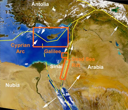
Figure 1. Location map of the Eastern Mediterranean showing the tectonic plates and sub-plates (white fonts), plate boundary, relative plate motion (white arrow), and study areas (orange).
Seismo-tectonics of the Cyprian Arc
The Cyprian Arc forms the plate boundary between the Anatolian plate in the north and the Nubian and Sinai plates in the south. We examine the tectonic setting and seismic activity along the arc in light of new geodetic studies indicating relative NE-SW plate motions across the arc. The first order tectonic variations are determined by the arc's geometry. The eastern arc, oriented sub-parallel to relative motion, is dominated by transcurrent tectonism. The western arc is oriented almost normal to relative plate motion and is subjected to convergent processes. Variations in the level and depth of seismic activity along the western arc suggest that the northwestern section of the arc represents a subduction boundary, whereas the southeastern section represents a collision boundary. The two tectonic domains of the western arc are separated by a NE-SW trending tear fault, which produces large earthquakes, such as the MW=6.8, 1996, Paphos Earthquake. We compare the geometrically similar Cyprian and Hellenic arcs and find significant differences in the rate, direction and type of convergence across the two arcs. The Hellenic Arc is subjected mainly to subduction, whereas the shorter Cyprian Arc is subjected to subduction, collision and transcurrent tectonic processes.
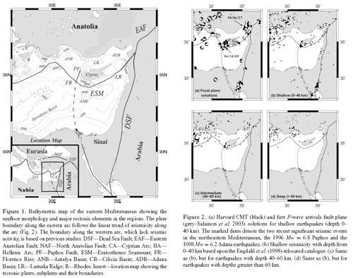
In another study (a href="publications/Arvidsson-et-al-1998.pdf">Arvidsson et al., 1998) we determine the centroid depths for the M-W = 6.8, October 9, 1996, Cyprus earthquake and its largest aftershock to 32 and 27 km, respectively, by modeling P and SH waveforms. These depths are consistent with shallow subduction as the African plate, west of Cyprus, penetrates beneath the Anatolian plate. We calculate the pole of rotation between Anatolia and Africa and determine their relative motion. The result indicates that, along the Cyprean Are, convergence between the African and Anatolian plate, in agreement with the observed seismicity, decreases from west to east. The northeasterly striking nodal plane is suggested as the plane on which the Cyprus earthquake ruptured since its strike agrees well with the derived plate motion vector. The faulting geometry suggests the emergence of a strike-slip tear fault within the African plate separating the continental Eratosthenes seamount south of Cyprus from the oceanic African lithosphere that subducts west of Cyprus.
More details at Wdowinski et al. (2006) and Arvidsson et al. (1998).
Morphological and Structural relations in the Galilee extensional domain, northern Israel
The Lower Galilee and the Yizre'el Valley, northern Israel, are an extensional domain that has been developing since the Miocene, prior and contemporaneously to the development of the Dead Sea Fault (DSF). It is a fan shaped region bounded in the east by the N-S trending main-trace of the DSF, in the north by the Bet-Kerem Fault system, and in the south by the NW-SE trending Carmel Fault. The study area is characterized by high relief topography that follows fault bounded blocks and flexures at a wavelength of tens of km. A synthesis of the morphologic-structural relations across the entire Galilee region suggests the following characteristics: (1) blocks within the Lower Galilee are tilted toward both the southern and northern boundaries, forming two asymmetrical half-graben structures, opposite facing, and oblique to one another. (2) The Lower Galilee's neighboring blocks, which are the Upper Galilee in the north and the Carmel block in the southwest, are topographically and structurally uplifted and tilted away from the Lower Galilee. (3) The southern half-graben, along the Carmel Fault, is topographically and structurally lower than the northern one. Combining structural and geological data with topographic analysis enables us to distinguish several stages of structural and morphological development in the region. Using a semi-quantitative evolutionary model, we explain the morpho-structural evolution of the region. Our results indicate that the Galilee developed as a set of two isostatically supported opposite facing half-grabens under varying stress fields. The southern one had started developing as early as the early Miocene prior to the formation of the DSF. The northern and younger one has been developing since the middle Pliocene as part of the extension process in the Galilee. Elevation differences between the two half-grabens and their bounding blocks are explained by differnces in isostatic subsidence due to sediemntary loading and uplift of the northern half-graben due to differential influences of the regional folding.
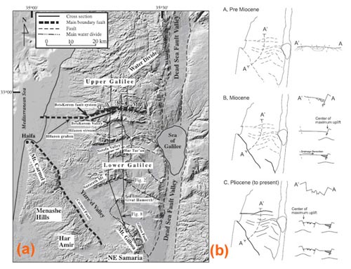
Figure 1 — (a) General location map (Israel grid). Database: Hall (1993, 1996). Inset: eastern Mediterranean tectonic setting. Dead Sea Faults (thin dashed lines) are drawn schematically. (b) Time evolution of the Galilee. Thick solid lines — Major boundary faults. Thin solid lines — secondary faults. Dashed lines — future location of faults. Shaded areas in cross sections - sedimentary and volcanic fill. A. Pre Miocene: Low relief terrain dominated the topography following the development during the Oligocene of an erosional plain. Cross section on right shows topography (black line) and truncated pre-Eocene structure (gray lines). B. Miocene: The formation of the Carmel Block along the Carmel Fault and the development of the southern half-graben. Top cross section shows the structure of the half-graben unit. Location of center of isostatic uplift due to normal faulting is shown in the middle cross section. Following the formation of the half-graben, drainage systems develop and transport sediment from north to south. Sediments and volcanics accumulate in the half-graben and the isostatic uplift is reduced, as demonstrated by the less arched line below the right side of the cross section (lower cross section). Notice that the topography of Lower Galilee tilts to the south into the Yizre'el Valley. C. Pliocene to recent: The formation of the Bet-Kerem Fault system and the northern boundary of the Lower Galilee. Inner Lower Galilee structures were formed at this stage as well. Upper cross section shows schematic structure of the region. The arched line below the left side of the middle cross section demonstrates Isostatic compensation. Because there is very little sedimentary fill in the northern valleys, there is no subsidence due to sedimentary loading. Arching of the western margin of the Dead Sea Fault uplifts the northern half-graben (lower cross section). This structural arch does not affect the southern half-graben because it lies west of the arching axis.
More details at Matmon et al. (2003).
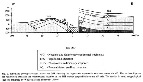
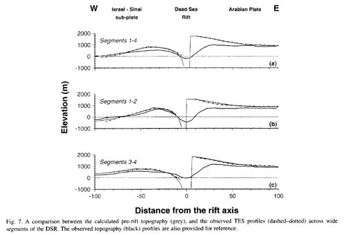
Systematic analysis and Kinematic modelling of large-scale structural asymmetry across the Dead Sea Rift
The Dead Sea Rift (DSR) is one of the deepest continental depressions on the Earth's surface and is the best example of a continental rift lying along a transform plate boundary (the Dead Sea Transform). Its is characterized by large-scale topographic and structural asymmetries: the rift's eastern side is flexed upward toward the axis and its overall shape resembles an uplifted shoulder; the western side of the rift is flexed down toward the axis and its overall shape resembles a wide arch. We use a kinematic model of the lithosphere to explain the cumulative deformation of the pre-rift topography in response to two tectonic processes: normal faulting due to lithospheric extension and isostatic uplift. The model considers the sum relief of three surfaces: relief that existed prior to the formation of the rift (initial topography), relief created by slip along a curved normal boundary fault (kinematic topography), and relief created by isostatic response of the lithosphere to this faulting and to an additional unmodelled load (isostatic topography). The model predicts the observed structure across the rift only when we considered a significant additional load, comparable in magnitude to the load induced by the kinematic topography. The additional load reflects the negative mass anomaly of the 8-10-km-deep Dead Sea Basin, which is filled with unconsolidated sediments. By constraining the model with the structural observations, we determined that the extension perpendicular to the rift axis lies in the range 1-4 km in the northern half of the rift and 2-8 km in the southern half. The model also explains other observations across the DSR, such as the configuration of the three present-day regional drainage systems and the observed low-magnitude upward deflection of the Moho beneath the rift.