Year 1 progress report 15/Sept./1995 - 14/Sept./1996
NASA Mission to Planet Earth (MTPE)
Topography and Surface
Change Program
Dr. Dean Whitman, Florida International University (FIU)
Dr. Timothy Gubbels, Hughes Applied Information Systems (HAIS)
Dr. Grenville Draper, Florida International University
Linda Powell, Florida International University
The topography of central Florida is an excellent example of a continental landscape dominated by a single geomorphic process: karst, an array of landforms formed in response to chemical weathering and dissolution of carbonate rock. Because the rocks of the Florida platform are almost entirely undeformed and regional topographic gradients are low, karst landforms form the primary topographic signal in the region. Central Florida thus provides a unique natural laboratory to study this type of landform evolution uncontaminated by fluvial and tectonic "noise".
Sinkholes are an ubiquitous feature of karst terrains and result from the subsidence or collapse of surficial material into subsurface cavities. They constitute a major hazard in central and northern Florida. The goal of this project is to utilize geographic information systems (GIS), digital imagery, and modern techniques of digital elevation model (DEM) construction and analysis to characterize sinkhole occurrence patterns in space and time, study precollapse topographic signatures and to identify highly hazardous regions of sinkhole collapse. This project is unique in that we are studying the process of, and topographic response to, sinkhole development at scales ranging from tens of centimeters to hundreds of kilometers.
The karst processes of central Florida are profoundly influenced by the region's complex hydrogeology. In this region, two distinct aquifer systems exist. The principal aquifer system, the Floridan, is a regionally extensive, confined aquifer which is situated within Eocene to Miocene age limestones which have been subjected to extensive dissolution and cavity formation. The Floridan aquifer provides the principle municipal and agricultural water supply for much of central and northern Florida, and spatial and temporal variations in its potentiometric surface are often related to groundwater withdrawal. The Floridan aquifer is capped by a variable thickness upper confining unit composed of Miocene clay rich clastic sediments. Near the surface, a discontinuous unconfined aquifer system exists within the highly permeable unconsolidated clastic cover. In contrast to the Floridan, the water tables of these surficial aquifers are more directly influenced by changes in rainfall, runoff, and landuse. Sinkhole formation is integrally related to the interplay of these aquifer systems. Sinkholes generally occur due to collapse of overlying material into preexisting cavities within the underlying limestones. Many of these sinkholes can form catastrophically and can be triggered by various forcing factors including rises in the surficial water table increasing the load on the underlying units, or by a drops in the potentiometric surface of the Floridan decreasing support from below. Since much of the topography and landforms of central Florida have developed over the past several million years due to similar karst processes, studying these features will help us better understand the regional potential for sinkhole hazard.
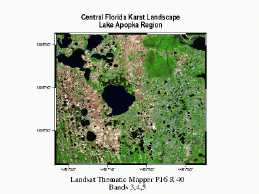
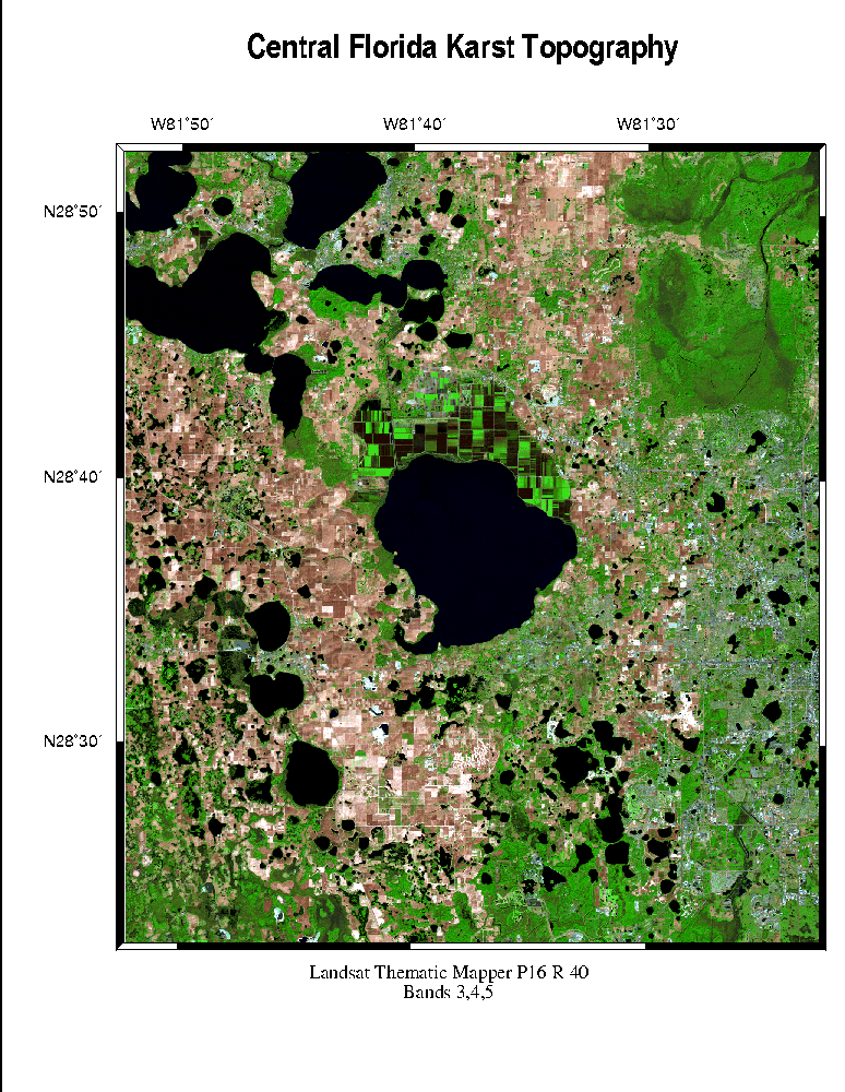
This report describes progress during year one of this three year project. The first year of this research was primarily oriented toward ingesting available digital data into a geographic information system, identifying a primary study area, planning and supporting a SLICER/ATM deployment, and initial data analysis. A primary focus area in central Florida was identified on the basis of a preliminary regional analysis, reported sinkhole occurrence, and the availability of 7.5' USGS digital elevation models and digital orthophotos. This focus area straddles Lake Apopka ( 28.6° N, 81.6° W) in the central highlands of the Florida peninsula and lies adjacent to the rapidly growing Orlando metropolitan area. Initial work completed includes compilation of existing data, planning and deployment of an airborne laser altimetry mission, generation of a high quality DEM from topographic contours, and some preliminary morphometric analysis. Preliminary results were presented at the 1996, AGU Spring meeting.
Several high quality vector and raster data sets were purchased or obtained free of charge from national, state, and local government agencies. These include a database of reported sinkhole occurrence in Florida, vector datasets of geographic, hypsometric, hydrographic, cultural features, digital elevation models, digital aerial photographs, and digital satellite images. Detailed descriptions and applications are given below.
A database of reported sinkholes in Florida was obtained from the Florida Geologic Survey. This dataset was originally compiled by the Florida Sinkhole Research Institute (now defunct) from observations and news reports of over 1900 sinkholes occurring between 1961 and 1991. The database contains attributes on information such as date and time of occurrence, location, size and shape, circumstances of collapse, terrain characteristics, and local geology and hydrogeology, and it is the most comprehensive dataset of its type available. This dataset has been utilized for a number of years by researchers investigating sinkhole occurrence in this region. We observe, however, that the reported occurrences of sinkholes in this dataset appear to be spatially biased towards population centers areas in the Tampa and Orlando metropolitan areas. A primary goal of this project will be to use topography data to evaluate sinkhole hazard in a non-spatially biased manner.
A large and comprehensive vector dataset in ARC/INFO format was obtained from the South Florida, Southwest Florida, and St Johns River Water Management Districts. These data sets include topographic contours, hydrologic and hydrogeologic features, geologic and soil units, 1973 and 1990 land use/landcover boundaries, horizontal control points, transportation features, county, district and public land boundaries, and census tracts and were compiled from 1:24000, 1:100000, 1:250000, and 1:5000000 scale maps and digital line graphs from the USGS, State of Florida water management districts, Florida Geologic Survey, U. S. Soil conservation service, FEMA, and the University of Florida. Together, these datasets cover most of the state of Florida at 1:24,000 scale and represent over 6 gigabytes of data. We are using these data sets as source data for morphometric analysis, digital elevation model construction, land cover interpretation, and satellite image geocoding.
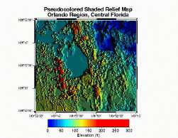
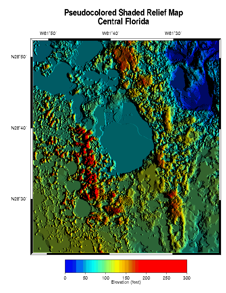
Digital elevation models (DEM) at 1:250,000 and 1:24,000 scales were obtained from the U. S. Geological Survey. The 1:250,000 scale DEMs cover the whole of the state of Florida, have a horizontal resolution of 3 arc-seconds (~90 m) and a vertical resolution of 1 meter. The 1:24,000 scale DEMs are available for only a limited number of quadrangles in central Florida. These DEMs are being used for morphometric and hydrologic analysis, and for visualization.
30 3.75-minute Digital orthophoto quadrangles (DOQ) were purchased from the USGS. These images have a 1 meter horizontal resolution and have excellent cartographic control. The DOQs were used extensively in planning the airborne laser altimetry deployment. They are currently being used to precision geocode the TM imagery and will be used as an aid in interpreting the altimetry data.
Cloud free Landsat TM scenes acquired in 1984 and 1986 were purchased for the study area and additional scenes acquired in 1988, 1990, 1992, 1994, and 1996 have been ordered through the MTPE special purchase program. These datasets have been used in planning the altimetry deployment and will be used in a detailed change analysis to document the encroachment of the Orlando metropolitan area into sinkhole prone areas to the west.
These datasets were checked for errors, corrected if necessary, projected into a standard map projection (UTM zone 17, NAD83 datum), and compiled into a standard GIS (ARC/INFO) compatible format.
An airborne laser altimetry mission was deployed in the study area in mid-November, 1995. The study area was selected based on the prominence of karst topography, density of reported sinkholes, availability of data, and proximity to areas of intense land use change. The deployment employed both helical (ATM) and along-track scanners (SLICER) from NASA Wallops, VA and Goddard SFC facilities and included flights at 500 and 5000 m elevation. Over 500 km of data at low altitude and 100 km at high altitude were collected. The deployment was immediately followed up with a ground level site visit. These data sets will be used to produce very high resolution DEMs in selected areas to characterize topography at the < 5 m horizontal scale and for the detection of incipient features related to sinkhole formation. This data is currently being reprocessed to allow rapid browsing and analysis.
We are currently completing work an a high quality, 30 m horizontal resolution DEM in the study focus area. This DEM is being generated from digitized 5 foot topographic contours and water bodies on USGS 7.5' maps and is in general as good or of higher quality than the comparable 7.5 ' USGS DEMs which are available in only limited areas. Currently, this DEM covers an area of 30' x 30 '. This high quality DEM is providing the basis for hydrological and morphometric analysis at this scale.
In order to characterize the spatial distribution of karst features, we have selected from our database of 5' topographic contours a subset consisting of the largest contour surrounding closed topographic depressions. We are currently examining the size-frequency distributions of these features and relationships between contour elevation, perimeter, and enclosed area. From this analysis, we hope to understand the scaling relationships and spatial distribution of karst features in this region.
We are currently examining the relationship of lake surface elevations in this region to the hydraulic head surfaces of Floridan and surficial aquifer systems. Examination of the spatial variation in lake level elevations from the digital topography and satellite imagery indicates that lake level elevations can vary greatly over relatively short distances. Preliminary analysis suggests that the lake levels are bimodally distributed with the higher elevation population related to surficial aquifer levels and the lower elevation population related to the Floridan potentiometric surface. This may indicate that lateral gradients in the elevation of the surficial water table vary considerably and that the vertical head difference between the Floridan and surficial aquifer systems can be large in areas. These simple observations have caused us to begin "tuning in" to existing hydrological and climatological databases and to integrating this data into the topographic analysis. Since this study area straddles the boundaries of three separate water management districts (South Florida, Southwest Florida, and St. Johns River), formation of a complete picture of the subsurface hydrology will require integration of data from diverse sources into our geographic information system.
In the near term, we plan to continue our spatial and morphometric analysis of our 30 m DEM. This will include standard hypsometric and fractal analysis of the digital topography, automated drainage basin delineation and other hydrologic modeling, and spatial clustering and alignment analysis. In addition, we will soon be purchasing a SPOT stereo pair and by utilizing digital photogrametrical methods we will be producing a 10 m resolution DEM for the region. With the acquisition of the collected altimetry data, we hope to extend these analysis to the micro-topographic scale. This information will be incorporated with other spatial information such as soil units, landuse boundaries, and reported sinkhole locations to determine spatial relationships between topography, geology, landuse, and sinkhole occurrence.
We will soon be performing a detailed landuse change analysis study in the region using Landsat TM scenes collected at 2 year intervals between 1984 and 1996. We will be investigating the history of landuse changes in this region. In the western part of the study area, that history has largely been one of conversion of the natural landscape to farmland and orchards. In the eastern part of the study area, the history has been one of conversion of farmland and orchards to suburban/urban use (on the fringes of Orlando). We are particularly interested in the impact of landuse changes on sinkhole hazard as these urban areas encroach on the higher elevation topography of the central Florida peninsula. This landuse change study will form the basis of graduate student Linda Powell's Masters thesis.