Sea level rise and coastal flooding hazard
Flooding hazard due to sea level rise (SLR) is a global problem. It affects about 10% of the Earth’s population, roughly 700 million people, who live in low-lying coastal areas. In the US alone, 5.7 million people are living on land within 4 feet of high tide and are at high risk of coastal flooding. Despite the global SLR problem, coastal flooding hazard is a local problem, due to local elevation and elevation change (subsidence) of coastal communities, regional variations in the rate of SLR, as well as possible exposure to storm surge induced by extreme weather events.
The Florida coast is one of the most vulnerable areas to SLR due to its low elevation, large population concentrations, and economic vulnerability. A large portion of the state’s population (2.2. million people) lives in low-lying coastal areas prone to coastal flooding (below 4 feet). The state is also highly vulnerable to sea level rise in terms of infrastructure and residential property exposure to coastal flooding. The rate of sea level rise along the Florida coast has accelerated since 2000 from 2-2.5 mm/yr for the period 1913-2016 to 6-8 mm/yr for the period 2000-2016, which is significantly higher that the global rate of sea level rise (Michum et al., 2017). The causes for the higher rates of sea level rise along the Florida coast and projected sea level rise until the end of the century are provided by Michum et al. (2017).
In another study, we focus on the increasing flooding hazard in Miami Beach, which has caused severe property damage and significant disruptions to daily life (Wdowinski et al., 2016; Figure 1). We evaluated the flooding frequency and its causes by analyzing tide and rain gauges, media reports, insurance claims, and photo records from Miami Beach acquired during 1998-2013. Our analysis indicated that significant changes in flooding frequency occurred after 2006, in which rain-induced events increased by 33% and tide-induced events increased by more than 400% (Figure 1). We also analyzed tide gauge records from southeast Florida and detected a decadal-scale accelerating rate of SLR. The average pre-2006 rate is 3±2 mm/yr, similar to the global long-term rate of SLR, whereas after 2006, the average rate of SLR in southeast Florida rose to 9±4 mm/yr. Our results suggest that engineering solutions to SLR should rely on regional SLR rate projections and not only on the commonly used global SLR projections.
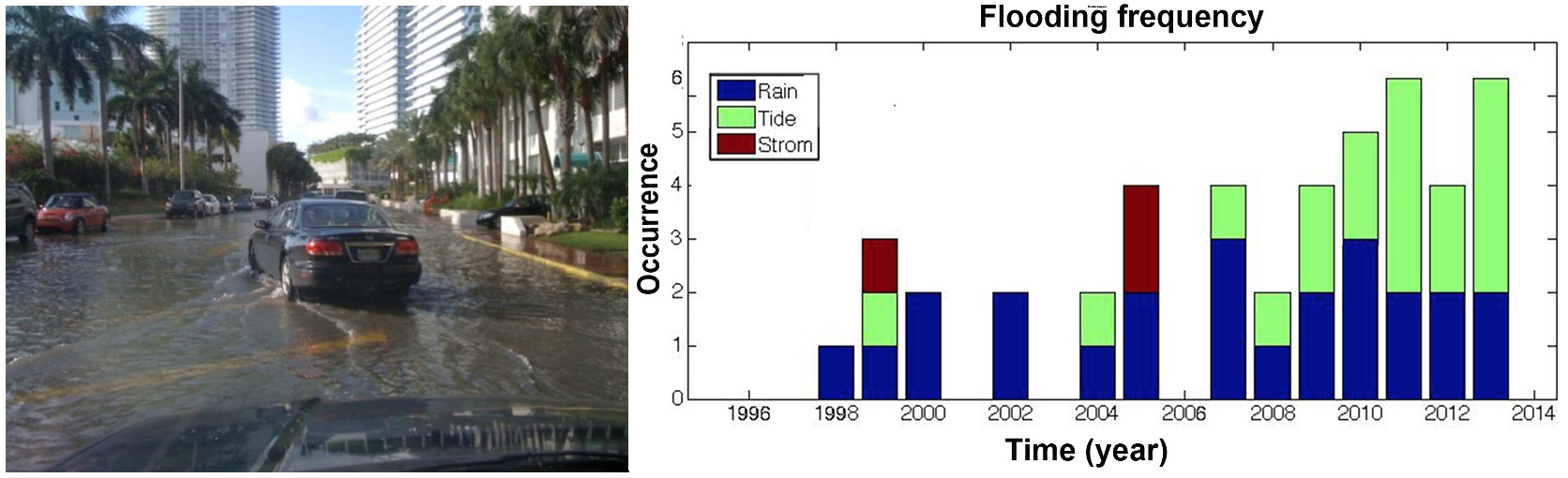
Figure 1. (left) “Sunny sky” flooding in Miami Beach. (right) Annual flooding occurrence in Miami Beach between 1998-2013 indicating a significant increase in tide flooding events (green) since 2006.
Sea level rise publications: Wdowinski et al. (2016); Mitchum et al. (2017); Parkinson and Wdowinski (2022)
Coastal subsidence
Land subsidence occurs in response to both deep and shallow deformation processes, including tectonics, Glacial Isostatic Adjustments (GIA), sediment compaction, and groundwater extraction. When subsidence occurs in coastal areas, the combined effect of SLR and subsidence results in higher relative SLR rates and increased coastal flooding hazards. In urban areas, high rates of relative SLR can increase flooding frequency, which can cause significant disruption to daily life (e.g., Wdowinski et al. 2016). In flat coastal rural areas, land subsidence can result in land loss, as occurs along the Louisiana coast.
Geodetic measurements of land subsidence in coastal areas provide the most accurate assessments for higher relative SLR rates and their implied flooding hazard. Our study of land subsidence along the Venice Lagoon based combined GPS and InSAR observations indicated that the city of Venice subsides at a rate of 1–2 mm/yr, whereas some sections of the lagoon subside at higher rates of 3–4 mm/yr (Figure 2; Bock et al. 2012). These results indicate that the relative rate of SLR in Venice and its surroundings is higher than the global mean and hence imposes a higher flooding hazard to the city, which is already subjected to frequent flooding events, known as Acqua Alta. In another study, we used InSAR observations from 1993-1999 to detect land subsidence in Norfolk (VA) and Miami Beach (FL), which are two coastal communities subjected to recurrence flooding (Fiasche and Wdowinski, 2020). The results of our study revealed that both communities were affected by localized subsidence with rates varying between 1-6 mm/yr in Norfolk and 1-3 mm/yr in Miami Beach. Currently, we are monitoring land subsidence along the southeast Florida coast (Wdowinski et al., 2020). More below.
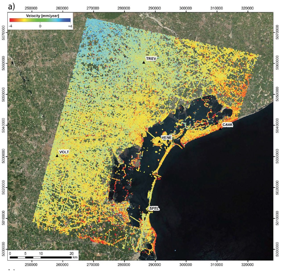
Figure 2. Land subsidence (in mm/yr) along the Venice Lagoon as detected from combined GPS and InSAR observations.
Coastal subsidence publications: Bock et al. (2012); Fiasche and Wdowinski (2020); Wdowinski et al. (2020);
Monitoring coastal subsidence in southeast Florida
Over the past decade, several coastal communities in southeast Florida have experienced a significant increase in flooding frequency, which has caused disturbance to property, commerce, and overall quality of life. The increased flooding frequency reflects the contribution of global, regional, and local processes that affect elevation difference between coastal communities and rising sea level. In a recent project funded by the state of Florida, we monitor coastal subsidence in southeast Florida using GPS and spaceborne radar observations, in order to evaluate the contribution of local subsidence to the increased coastal flooding hazard. As part of the project, we constructed a network of four continuously operating GPS (cGPS) stations that monitor land subsidence with accuracies of millimeters per year (Figure 3). Each station is equipped with a precise GPS antenna, a monument containing the antenna, solar panels, cellular communication, and an explanation plaque (Figure 4). The spaceborne radar observations enable the detection of building movements over wide areas, also with an accuracy of millimeters per year. Preliminary results of radar observation acquired during 1994-1999 reveal that localized subsidence occurs in Miami Beach with a magnitude of up to 3 mm/yr, in urban areas built on reclaimed marshland.
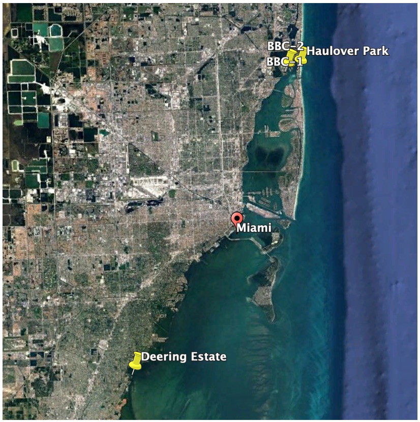
Figure 3. Location of four selected sites along the urban section of the Miami-Dade County for installing cGPS units and monitoring coastal subsidence.
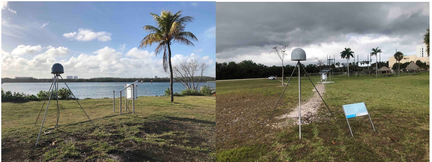
Figure 4. Pictures of cGPS stations in Haulover Park (left) and FIU BBC campus (right)..
Publications: Wdowinski et al. (2020).