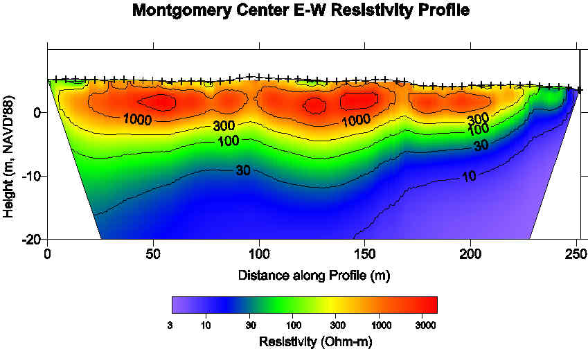
Geophysical methods provide cost-effective, noninvasive techniques for characterizing aquifer properties. We are using a AGI SWIFT/STING 28-electrode resistivity imaging system to explore innovative applications to environmental problems in South Florida. Current projects include investigations of submarine ground water discharge, saltwater intrusion, and azimuthal electrical anisotropy in the Biscayne aquifer.
Airborne LIDAR (acronym for LIght Detection and Ranging) is an emerging remote sensing technology which can accurately and inexpensively map surface topography over large areas. LIDAR systems operate by directing pulses of laser light toward the ground and detecting the return times of reflected or back-scattered pulses in order to determine ranges to the reflecting surface. This range data is then combined with navigational information of the aircraft in order to produce a detailed 3-dimensional representation of the Earth’s surface. LIDAR data has a wide range of applications the earth and environmental sciences and in urban planning. These include mapping of flood plains, identification of ground subsidence related to groundwater withdrawals, and detection of active fault scarps for determining seismic risk. For urban planning, LIDAR data may be used for mapping infrastructure, planning construction, and cataloging vegetation. For public information purposes, these data can be combined with advanced computer graphics and database technology to create realistic 3-D renderings of the urban landscape.
Current collaborative research with the International Hurricane Research Center focuses on focuses on applications of Airborne LIDAR topographic mapping to flooding from tropical cyclones in the SE United States. This research utilizes high resolution topography collected by FIU's Optech ALTM 1233 airborne LIDAR system in several Florida counties. Other ongoing applications of this technology include studies of beach erosion and land cover classification. For more information on this project, click HERE.
A project with NASA involves the application of high-resolution digital topographic data to the study of karst topography and the detection of incipient sinkhole formation in central Florida. Sinkholes are an ubiquitous feature of karst terrains and result from the subsidence or collapse of surficial material into subsurface cavities. They constitute a major hazard in central and northern Florida. The goal of this project is to utilize geographic information systems (GIS), digital imagery, airborne instrumentation, and modern techniques of digital elevation model (DEM) construction and analysis to characterize sinkhole occurrence patterns in space and time, study precollapse topographic signatures and to identify highly hazardous regions of sinkhole collapse. This project is unique in that we are studying the process of, and topographic response to, sinkhole development at scales ranging from tens of centimeters to hundreds of kilometers.
![]() Check out the
Online version of my talk at the 1997 GSA Annual
Meeting
Check out the
Online version of my talk at the 1997 GSA Annual
Meeting
A primary research interest is the crust and upper mantle structure, tectonics, and isostasy of young compressional mountain belts. Previous and current research centers on the gross lithospheric structure of the central Andean Plateau of Peru, Bolivia and Northwest Argentina and its relationship to along-strike changes in the tectonics, physiography and geologic history of this region. This research combines analysis of upper mantle seismic wave propagation with modeling of regional gravity data and digital topography.
Click HERE for Color figures for "The isostatic residual gravity anomaly of the central Andes 12 to 29 degrees S: A guide to interpreting crustal structure and deeper lithospheric processes" by D. Whitman, International Geology Review, , 41, 457-475, 1999.
Last revised 10/08