Global Navigation Satellite Systems (GNSS)
“GNSS” is a recent term used to describe the various satellite navigation systems, such as Global Positioning System (GPS), the Russian Globalnaya navigatsionnaya sputnikovaya sistema (GLONASS) and the European’s Galileo. Although these satellite systems were designed mainly for navigation, they were found to be very useful for precise positioning with sub-centimeter accuracy levels. GNSS also provides very high temporal resolution (up to sub-seconds), yielding key observations of time-dependent processes in the lithosphere, atmosphere, and ionosphere. A detailed summary of GNSS Geodesy contribution to Geophysics, Natural Hazards, Climate‚ and the Environment was provided in a book chapter by Bock and Wdowinski (2020). Some of my research that was devoted to GNSS time series and method development is listed below.
GNSS time series – High temporal resolution observations acquired by continuously operating GNSS stations allow us to detect both secular and transient crustal deformation patterns associated with various phenomena, including tectonics, volcanism, hydrology, and climate change. My studies of the first continuous GNSS network in California enabled me to detect and quantify different stages of the earthquake deformation cycle (Bock et al., 1994; 1997), develop the special filtering technique (Wdowinski et al., 1997), and quantify noise characteristics of continuous GNSS observations (Zhang et al., 1997).
Spatial filtering – Spatial filtering is a widely used technique for identifying a common noise to a regional set of GNSS stations using stacking techniques (Wdowinski et al., 1997). The common mode noise can be removed from GNSS time series and hence improve the observations’ signal-to-noise ratio (Figure 5). Spatial filtering was first applied to time series of daily positions (e.g., Wdowinski et al., 1997), but also to high rate (e.g., 1-10 Hz) series that are used to detect earthquake-induced dynamic movements (Yin and Wdowinski, 2013).
High rate GNSS and seismogeodesy – High-rate, ≥1 sample per second, instantaneous surveying with geodetic precision provides valuable information on dynamic crustal deformation during the passage of seismic waves. In a couple of studies, I used high rate GNSS observation to study dynamic deformation induced by the 2008 Ms= 8.0 Wenchuan earthquake (Yin et al., 2013) and the 2012 M = 7.6 Costa Rica earthquake (Yin and Wdowinski, 2013).
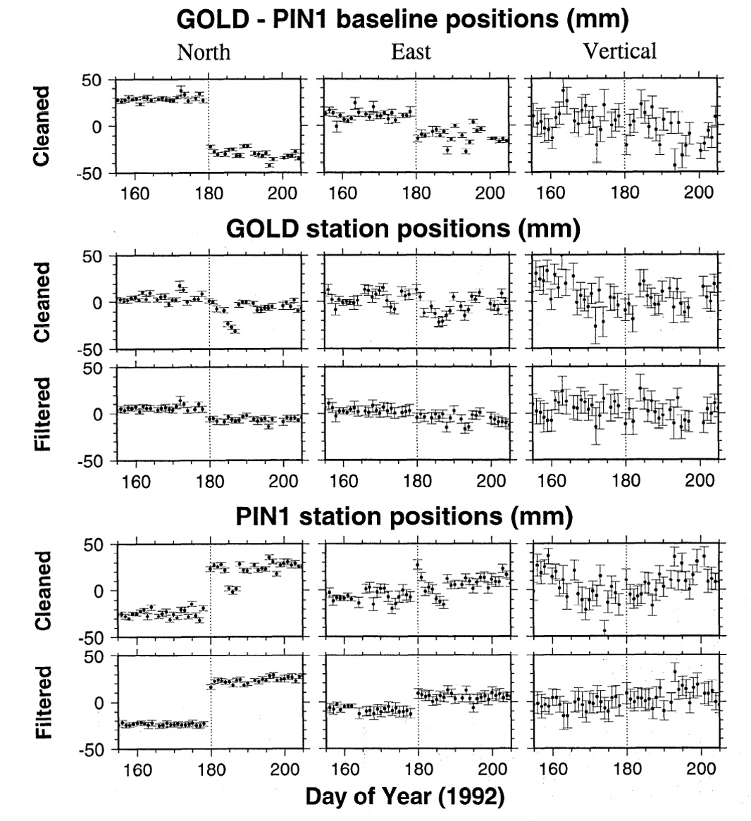
Figure 1: GPS time series of two continuously operating time series in California acquired 30 days before and 30 days after the 1992 M=7.2 Landers earthquake. The filtered time series of both sites show a significantly improves S/N ratio compared with the clean series. [Source: Wdowinski et al., 1997].
GPS research publications: Bock et al. (1993); Bock et al. (1997); Wdowinski et al. (1997); Zhang et al. (1997); Yin et al. (2013); Yin and Wdowinski (2014); Bock and wdowinski (2020);