Climate change
Climate change affects the livelihood of a large portion of the world’s population and impacts natural environments. Consequences include rising surface temperatures, continental ice melt, rising sea level, reduced water availability for human and natural consumption, and increased frequency of atmospheric and hydrological hazards, including tropical cyclones, hurricanes, heatwaves, droughts, and floods. Therefore, mitigating the degree and extent of climate change and forecasting trends are pressing issues for reducing societal and environmental vulnerabilities. Geodesy provides valuable observations on three climate change frontiers, continental ice melt, variations in continental water storage, and sea level rise. Geodetic observations can monitor the impact of climate changes, because they are capable of detecting vertical crustal displacements with sub-cm accuracy. Such displacements are often induced by atmospheric, hydrological, cryospheric, and oceanic load changes. My climate change research has contributed to all three geodetic climate research frontiers. The contribution to sea level rise is presented in the section Sea level rise and coastal flooding hazard. My research contributions to continental ice melt and variations in continental water storage are presented below.
My cryospheric research has focused on its effect on crustal deformation and on quantifying icecap melt in the northern Atlantic (Greenland and Iceland) using space geodesy (GPS and InSAR) observations to detect crustal uplift and infer hydrological mass balances using mechanical modeling. I applied this approach to observations from Greenland (Jiang et al., 2010; Yang et al., 2013) and Iceland (Zhao et al., 2014). In my continental water storage research, we applied similar methods to observe uplift around the Dead Sea, which has been induced by a rapid drop in the sea’s level (Nof et al., 2012) and Yangzhuoyong Lake in southeastern Tibet (Zhao et al., 2016). Recently, we investigated possible relations between vertical crustal movements and climate change by analyzing the relations between observed GPS vertical movements, predicted movements, and climatic indices, where we have long GPS time series (>20 years) (Wdowinski and van Dam, 2020). Our results suggest that long continuous GPS observations of vertical crustal displacements primarily driven by climate-related changes in water storage can serve as independent measures of regional-scale climate change in some cases, mainly in western north America.
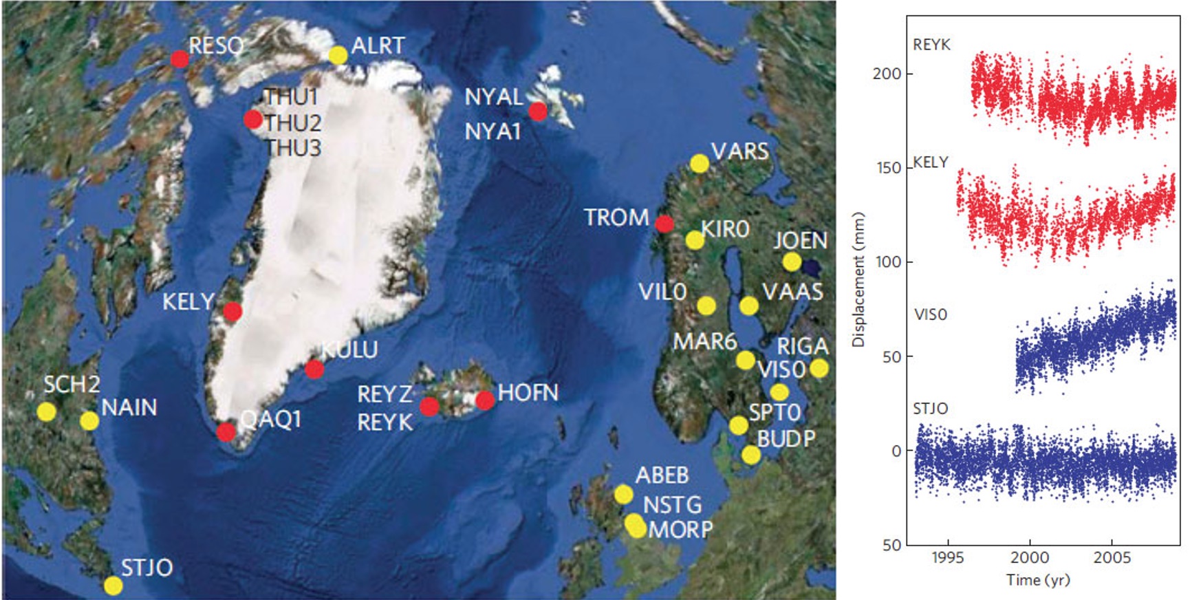
Figure 1. Accelerated crustal uplift of Greenland’s rocky margins. (left) Location of GPS sites used in this study. The red circles indicate sites with acceleration 0:5mm/yr/yr or greater; the yellow circles indicate acceleration less than this value. (right) Representative GPS time series for the North Atlantic region, showing site name and acceleration. The red (upper) time series (Greenland, Iceland) show positive acceleration and the blue (lower) time series (Fennoscandia, Canada) show no significant acceleration; for example, VISO shows uplift at an essentially constant rate. [Source: Jiang et al., 2010].
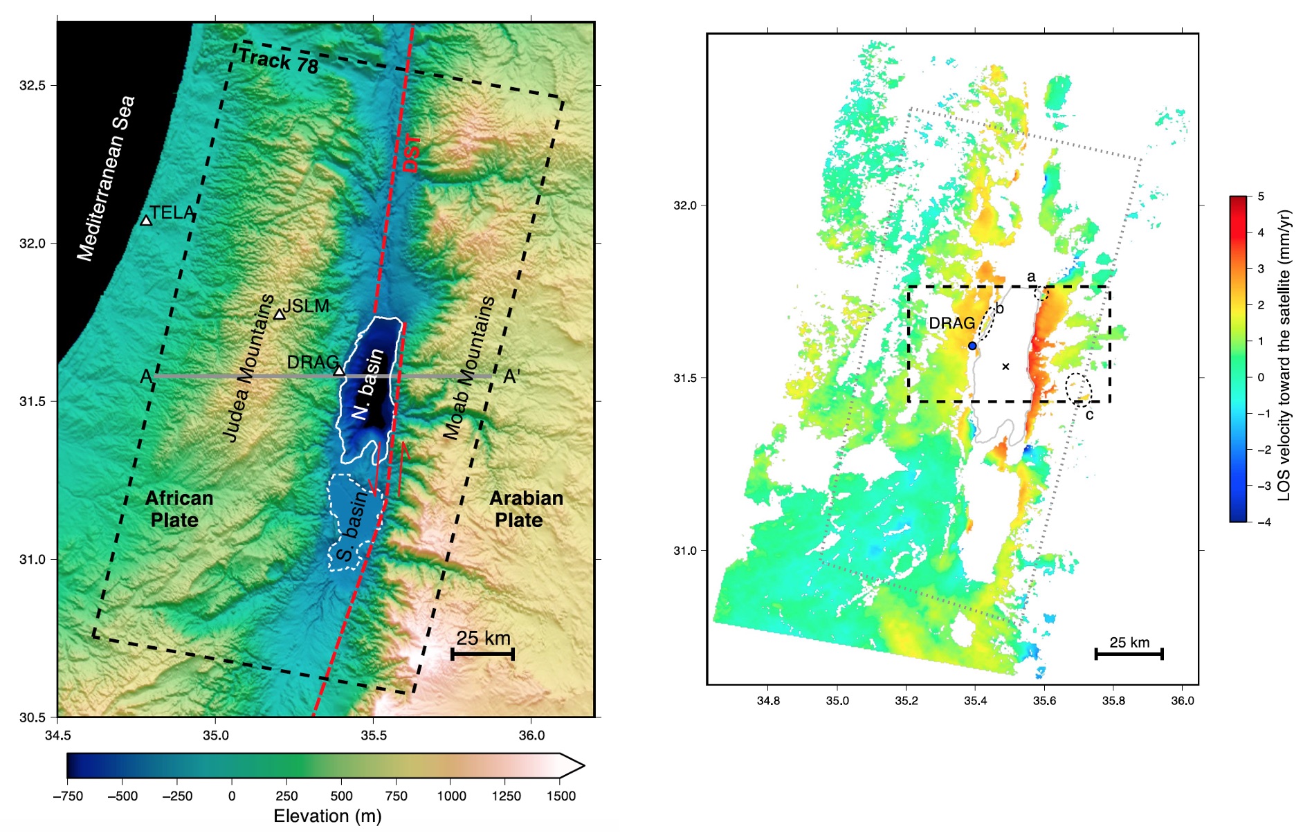
Figure 2. Crustal uplift in response to the Dead Sea lake level. (left) Location map of the Dead Sea. The dashed frame marks the footprint of the ERS-1/2 SAR data (Track 78). (right) LOS velocity map (positive toward satellite) showing an uplift along the Dead Sea shores.
Climate change publications: Jiang et al. (2010); Nof et al. (2012); Yang et al. (2013); Zhao et al. (2014); Zhao et al. (2016); Wdowinski and van Dam (2020);